
Street Names Recall People
- Description
-
This text that follows is the content of the attached PDF.
Weraroa Road
Weraroa Road was named for the Weraroa clearing. This had no heavy bush on it, only manuka, fern and flax etc. Weraroa means "the long burn” but Maoris of the mid 1800's had no memory of any fire.
 The clearing extended from over Queen Street between Weraroa Road and Salisbury Street, over Weraroa Road slightly, then veering east of Weraroa Road at Stuckey Street, then veering west to south to Hokio Beach Road just past C.D. Farm Road, then veering east on the side of Hokio Beach Road. The line crossed the railway and then went north crossing the railway at Bath Street crossing, angling to Salisbury Street - Queen Street corner.
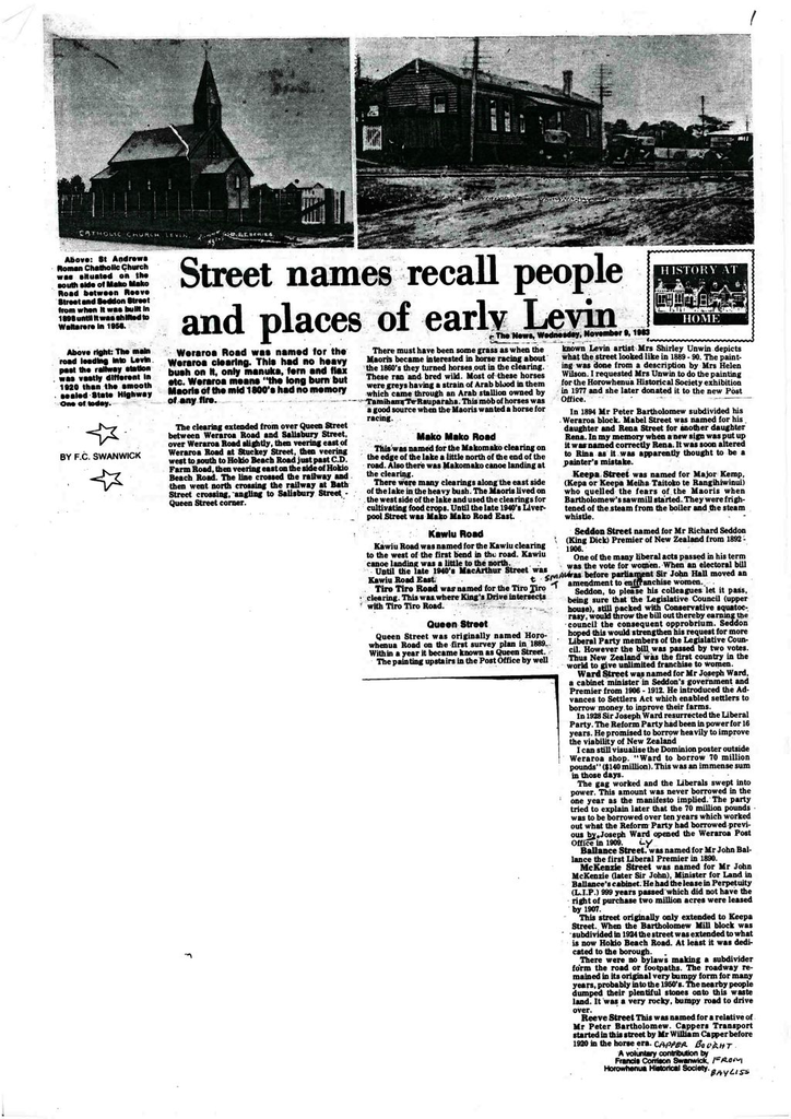
Photo at left: The main road leading into Levin past the railway station was vastly different in 1920 than the smooth sealed State Highway One of today.
There must have been some grass as when the Maoris became interested in horse racing about the 1860's they turned horses out in the clearing. These ran and bred wild. Most of these horses were greys having a strain of Arab blood in them which came through an Arab stallion owned by Tamihana Te Rauparaha. This mob of horses was a good source when the Maoris wanted a horse for racing.
Mako Mako Road
 This was named for the Makomako clearing on the edge of the lake a little north of the end of the road. Also there was Makomako canoe landing at the clearing.
 There were many clearings along the east side of the lake in the heavy bush. The Maoris lived on the west side of the lake and used the clearings for cultivating food crops. Until the last 1940's Liverpool Street was Mako Mako Road East.
Photo at left: St Andrews Roman Catholic Church was situated on the south side of Mako Mako Road between Reeve Street and Seddon Street from when it was built in 1898 until it was shifted to Waitarere in 1956.
Kawiu Road
Kawiu Road was named for the Kawiu clearing to the west of the first bend in the road. Kawiu canoe landing was a little to the north.
Until the last 1940's MacArthur Street was Kawiu Road East.
Tiro Tiro RoadTiro Tiro Road was named for the Tiro tiro clearing. This was where King's Drive intersects with Tiro Tiro Road.
Queen Street
Queen Street was originally named Horowhenua Road on the first survey plan in 1889. Within a year it became known as Queen Street.
The painting upstairs in the Post Office by well known Levin artist Mrs Shirley Unwin depicts what the street looked like in 1889 - 90. The painting was done from a description by Mrs Helen Wilson. I requested Mrs Unwin to do the painting for the Horowhenua Historical Society exhibition in 1977 and she later donated it to the new Post Office.
Mabel Street
In 1894 Mr Peter Bartholomew subdivided his Weraroa block. Mabel Street was named for his daughter and Rena Street for another daughter Rena. In my memory when a new sign was put up it was named correctly Rena. It was soon altered to Rina as it was apparently thought to be a painter's mistake.
Keepa Street
Keepa Street was named for Major Kemp, (Kepa or Keepa Meiha Taitoko te Rangihiwinui) who quelled the fears of the Maoris when Bartholomew's sawmill started. They were frightened of the steam from the boiler and the steam whistle.
Seddon Street
Seddon Street named for Mr Richard Seddon (King Dick) Premier of New Zealand from 1892 - 1906.
One of the many liberal acts passed in his term was the vote for women. When an electoral bill was before parliament Sir John Hall moved an amendment to enfranchise women.
Seddon, to please his colleagues let it pass, being sure that the Legislative Council (upper house), still packed with Conservative squatocrasy, would throw the bill out thereby earning the council the consequent opprobrium. Seddon hoped this would strengthen his request for more Liberal Party members of the Legislative Council. However the bill was passed by two votes. Thus New Zealand was the first country in the world to give unlimited franchise to women.
Ward Street
Ward Street was named for Mr Joseph Ward, a cabinet minister in Seddon's government and Premier from 1906 - 1912. He introduced the Advances to Settlers Act which enabled settlers to borrow money to improve their farms.
In 1928 Sir Joseph Ward resurrected the Liberal Party. The Reform Party had been in power for 16 years. He promised to borrow heavily to improve the viability of New Zealand.
I can still visualise the Dominion poster outside the Weraroa shop. "Ward to borrow 70 million pounds" ($140 million). This was an immense sum in those days.
The gag worked and the Liberals swept into power. This amount was never borrowed in the one year as the manifesto implied. The party tried to explain later that the 70 million pounds was to be borrowed over ten years which worked out what the Reform Party had borrowed previously. Joseph Ward opened the Weraroa Post Office in 1909.
Ballance Street
Ballance Street was named for Mr John Ballance the first Liberal Premier in 1890.
McKenzie Street
McKenzie Street was named for Mr John McKenzie (later Sir John), Minister for Land in Ballance's cabinet. He had the Lease in Perpetuity (L.I.P.) 999 years passed, which did not have the right of purchase. Two million acres were leased by 1907.
This street originally only extended to Keepa Street. When the Bartholomew Mill block was subdivided in 1924 the street was extended to what is now Hokio Beach Road. At least it was dedicated to the borough.
There were no bylaws making a subdivider form the road or footpaths. The roadway remained in its original very bumpy form for many years, probably into the 1950's. The nearby people dumped their plentiful stones onto this waste land. It was a very rocky, bumpy road to drive over.
Reeve Street
Reeve Street. This was named for a relative of Mr Peter Bartholomew. Cappers Transport started in this street by Mr William Capper before 1920 in the horse era.
Identification
Related items


Creation
- Created By
- Corrie Swanwick
Object rights
- License
- Attribution + Noncommercial + ShareAlike
Taxonomy
- Community Tags