
One Hundred Years in Levin - Part One
- Description
-
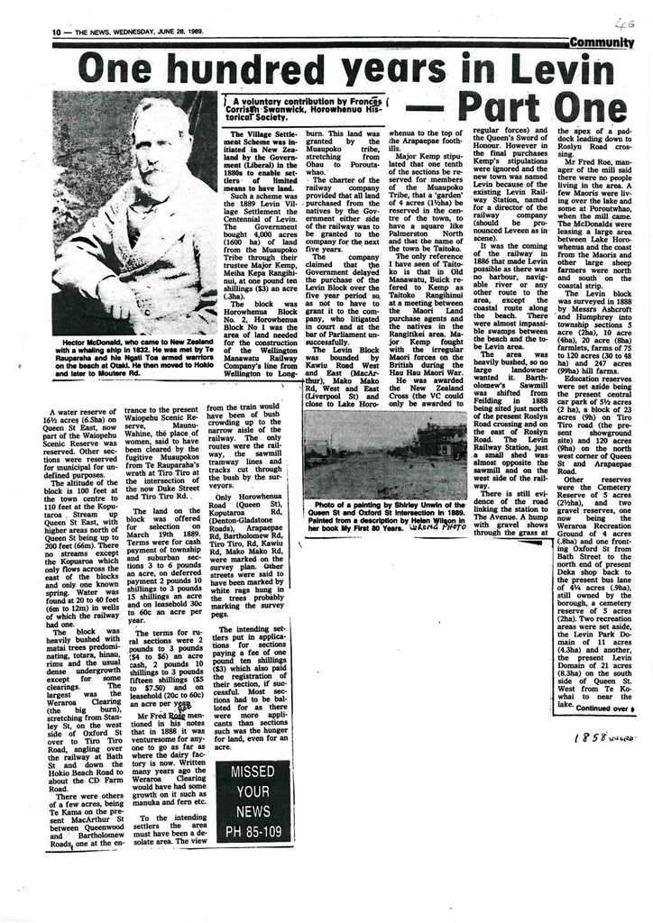
 Photo at left shows Hector McDonald who came to New Zealand with a whaling ship in 1832. He was met by Te Rauparaha and his Ngati Toa armed warriers on the beach at Otaki. He then moved to Hokio and later to Moutere Road.
Such a scheme was the 1889 Levin Village Settlement the Centennial of Levin. The Government bought 4,000 acres (1600 ha) of land from the Muaupoko Tribe through their trustee Major Kemp, Meiha Kepa Rangihinui, at one pound ten shillings ($3) an acre (.3ha).
The block was Horowhenua Block No. 2, Horowhenua Block No 1 was the area of land needed for the construction of the Wellington Manawatu Railway Company’s line from Wellington to Longburn. This land was granted by the Muaupoko tribe, stretching from Ohau to Poroutawhao.
The charter of the railway company provided that all land purchased from the natives by the Government either side of the railway was to be granted to the company for the next five years.
The company claimed that the Government delayed the purchase of the Levin Block over the five year period so, as not to have to grant it to the company, who litigated in court and at the bar of Parliament unsuccessfully.
The Levin Block was bounded by Kawiu Road West and East (MacArthur), Mako Mako Rd, West and East (Liverpool St) and close to Lake Horowhenua to the top of the Arapaepae foothills.
Major Kemp stipulated that one tenth served for members of the Muaupoko Tribe, that a ‘garden’ of 4 acres (1 ½ha) be reserved in the centre of the town, to have a square like Palmerston North and that the name of the town be Taitoko.
The only reference I have seen of Taitoko is that in Old Manawatu, Buick referred to Kemp as Taitoko Rangihinui at a meeting between the Maori Land purchase agents and the natives in the Rangitikei area. Major Kemp fought with the irregular Maori forces on the British during the Hau Hau Maori War.
He was awarded the New Zealand Cross (the VC could only be awarded to regular forces) and the Queen’s Sword of Honour. However in the final purchases Kemp’s stipulations were ignored and the new town was named Levin because of the existing Levin Railway Station, named for a director of the railway company (should be pronounced Leveen as in scene).
It was the coming of the railway in 1886 that made Levin possible as there was no harbour, navigable river or any other route to the area, except the coastal route along the beach. There were almost impassable swamps between the beach and the to be Levin area.
The area was heavily bushed, so no large landowner wanted it. Bartholomew’s Sawmill was shifted from Feilding in 1888 being sited just north of the present Roslyn Road crossing and on the east of Roslyn Road. The Levin Railway Station, just a small shed, was almost opposite the sawmill and on the west side of the railway.
There is still evidence of the road linking the station to The Avenue. A hump with gravel shows through the grass at the apex of a paddock leading down to Roslyn Road crossing.
Mr Fred Roe, manager of the mill said there were no people living in the area. A few Maoris were living over the lake and some at Poroutawhao, when the mill came. The McDonalds were leasing a large area between Lake Horowhenua and the coast from the Maoris and other large sheep farmers were north and south on the coastal strip.
The Levin block was surveyed in 1888 by Messrs Ashcroft and Humphrey into township sections 5 acre (2ha), 10 acre (4ha), 20 acre (8ha) farmlets, farms of 75 to 120 acres (30 to 48 ha) and 247 acres (99ha) hill farms.
Education reserves were set aside being the present central car park of 5 ½ acres (2 ha), a block of 23 acres (9h) on Tiro Tiro Road (the present showground site) and 129 acres (9ha) on the north west corner of Queen St and Arapaepae Road.
Other reserves were the Cemetery Reserve of 5 acres (2 ½ ha), and two gravel reserves, one now being the Weraroa Recreation Ground of 4 acres (.8ha) and one fronting Oxford St from Bath Street to the north end of present Deka shop back to the present bus lane of 4 ¼ acres (.9ha) still owned by the borough. Two recreation areas were set aside, the Levin Park Domain of 11 acres (4.3ha) and another, the present Levin Domain of 21 acres (8.3ha) on the south side of Queen St. West from Te Kowhai to near the lake.
A water reserve of 16 ½ acres (6.5ha) on Queen St East, now part of Waiopehu Scenic Reserve was established. Other sections were reserved for municipal for undefined purposes.
The altitude of the block is 100 feet at the town centre to 110 feet at the Koputaroa Stream up Queen St East, with higher areas north of Queen St being up to 200 feet (66m). There no streams except the Koputaroa which only flows across the east of the blocks and only one known spring. Water was found at 20 to 40 feet (6m to 12m ) in wells of which the railway had one.
The block was heavily bushed with matai trees predominating, totara, hinau, rimu and the usual dense undergrowth except for some clearings. The largest was the Weraroa Clearing (the big burn), stretching from Stanley St, on the west side of Oxford St over to Tiro Tiro Road, angling over the railway at Bath St and down the Hokio Beach Road to about the CD Farm Road.
There were others of a few acres, being Te Kama on the present MacArthur St between Queenwood and Bartholomew Roads, one at the entrance to the present Waiopehu Scenic Reserve, Maunu-Wahine, the place of women, said to have been cleared by the fugitive Muaupokos from Te Rauparaha’s wrath at Tiro Tiro at the intersection of the now Duke Street and Tiro Tiro Rd.
The land on the block was offered for selection on March 19th 1889. Terms were for cash payment of township and suburban sections 3 to 6 pounds an acre, on deferred payment 2 pounds 10 shillings to 3 pounds 15 shillings an acre and on leasehold 30c to 60c an acre per year.
The terms for rural sections were 2 pounds to 3 pounds ($4 to $6) an acre cash, 2 pounds 10 shillings to 3 pounds fifteen shillings ($5 to $7.50) and on leasehold (20c to 60c) an acre per year.
Mr Fred Roe mentioned in his notes that in 1888 it was venturesome for anyone to go as far as where the dairy factory is now. Written many years ago the Weraroa Clearing would have had some growth on it such as manuka and fern etc.
To the intending settlers the area must have been a desolate area. The view from the train would have been of bush crowding up to the narrow aisle of the railway. The only routes were the railway, the sawmill tramway lines and tracks cut through the bush by the surveyors.
Only Horowhenua Road (Queen St), Koputaroa Rd, (Denton-Gladstone Roads), Arapaepae Rd, Bartholomew Rd, Tiro Tiro Rd, Kawiu Rd, Mako Mako Rd, were marked on the survey plan. Other streets were said to have been marked by white rags hung in the trees probably marking the survey pegs.
The intending settlers put in applications for sections paying a fee of one pound ten shillings ($3) which also paid the registration of their section, if successful. Most sections had to be balloted for as there were more applicants than sections such was the hunger for land, even for an acre.
THE NEWS, WEDNESDAY, JUNE 28, 1989
Identification
- Date
- June 28, 1989
Related items


Creation
- Created By
- Corrie Swanwick
Object rights
- License
- Attribution + Noncommercial + ShareAlike