
Eels, Europe and early settlers
- Description
-
Eels, Europe and early settlers
13v DAVID HARRIS
The street names of north-west Levin suggest a panorama from early Maori times through European settlement to the present day.
Tiro Tiro was a man-made clearing where today's road intersects Kings Drive. MuaUpoko grew vegetables there; in 1888 there were still a few whare On the site. Kawiu was a much larger space; it was also the name of the nearby canoe landing. The Word `kawhiu' refers to a scaffolding for drying eels which was a notable - land-mark. Later the 'h' was dropped (coincidentally kawiu means ‘to be shrunk', which, of course, is what happened to the eels on the rack). No doubt they were still plentiful in the early 1870s, by which time an Italian man named Nicola Sciascia had arrived in Horowhenua. He pilotted ocean-going vessels up the Manawatu River. After marriage to Foxton's Rina McGregor, their son John De Tomba Sciascia was born in 1884. John served in World War One and was injured in the Battle of the Somme. While recovering in an English hospital, he met Alice Stonehouse, a nurse whom he married and brought to New Zealand. After raising 10 children at Koputaroa, they settled on the two and a half acre block which now bears their names.
The Ministry of Works employed John Sciascia as an overseer in the depression years when tent cities (so-called single men's camps) were established near major work sites. His team was involved in the reconstruction of the main highway near Napier after the 1931 quake, as well as the building of the Ohakea air force base, and the Whirokino trestle bridge near Foxton. This enthusiasm for construction must have been passed on to his sons; from 1951 to the early 1990's they operated the major commercial building firm here. Their workforce, which numbered about 50 at its peak, built a number of prominent local buildings including the War Veterans', Horne, Horowhenua Hospital, Waiopehu College as well as banks, churches and schools. The most renowned building of the English city of York is its Gothic Style cathedral, with a stained glass window the size of a tennis court. The city is unique as the coronation venue of the Roman Emperor Constantine the Great — the only time this happened outside Rome. It's city wails from that era still stand; one travel writer says tourists today will, however, encounter greater obstruction from the layout of the streets: windy, rarely labelled and the longer ones changing names block-by-block! The former Roman fortress of Chester -- a bulwark against the Welsh -- has similarly enduring walls. Lancaster Street's link with York Street gives a picture from history. The Lancaster and York families fought for the English crown in the War of the Roses till enmity was dissolved by the marriage of Henry VII, the Lancastrian, to Elizabeth of York.
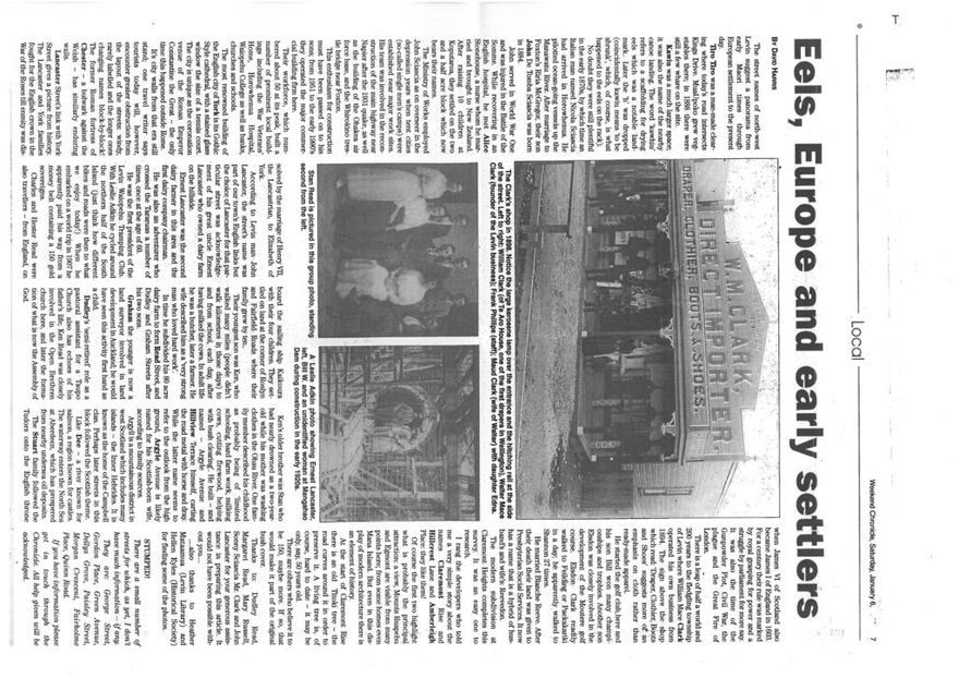
Picture: The Clark's shop in 1898. Notice the large kerosene lamp over the entrance and the hitching rail at the Side of the street Left to right: William Clark (of Te Aro House, one of the first drapers in Wellington), Walter Mace Clark (founder of the Levin business); Frank Phillips (staff); Maud Clark (wife of Walter) with daughter Edna.
According to Levin man John Lancaster, the street's name was part of our town's English links but the choice of Lancaster for that particular street was acknowledgement of his great-uncle Ernest Lancaster who owned a dairy farm on the hillside. Ernest Lancaster was the second dairy farmer in this area and - the first dairy company chairman. He was also an adventurer who crossed the Tararuas a number of times, once at the age of 60. He was the first president of the Levin Waiopehu Tramping Club. With Leslie Adkin he cycled around the northern half of the South Island'(just think how different bikes and roads were then to what we enjoy today!) When he embarked on a world trip in 1907 he apparently paid his way from a money belt containing a 150 gold sovereigns. Charles and Hester Read were also travellers — from England, on board the sailing ship Kaikoura with their four children. They settled on land at the corner of Roslyn and Fairfield Roads Where their family grew by ten.. Their youngest son was Ken, who walked many miles (people didn't walk kilometres in those days) to and from school, each day, after having milked the cows. In adult life he was a butcher, later a farmer. He wife described him as 'a 'very strong man who loved hard work'. In time he subdivided his 80 acre dairy farm to form Read Street, and Dudley and Graham Streets after his two sons Graham the younger is now a land surveyor involved in land development in Auckland; he would have seen this activity first hand as a child. Dudley's 'semi-retired' role as a pastoral assistant for a Taupo Church also has echoes of his father's life; Ken Read was closely involved in the Open Brethren church here, and later the formation of what is now the Assembly of God.
Stan Read is pictured in this group photo, standing

Photo A Leslie Adkin photo showing Ernest Lancaster, second from the left. left, Bill W. and an unidentified woman at Mangahao Dam during construction in the early 1920s.
Ken's older brother was Stan who had nearly drowned as a two-year-old while his mother was washing clothes in the Ohau River. One family member described his childhood as probably being of 'limited schooling, hard farm work, milking cows, cutting firewood, helping with bush clearing'. He built — and named -- Argyle Avenue and Hillview Terrace himself, carting the road metal with horse and dray. While the latter name seems to refer to the outlook from the high ground, Argyle Avenue is likely named for his Scottish-born wife, according to family sources. Argyll is a mountainous district in west Scotland which includes many islands -- the inner Hebrides. It is known as the home of the Campbell clan. Perhaps later streets in this block followed the Scottish theme. Like Dee -- a river known for salmon, a region known for castles. The waterway enters the North Sea at Aberdeen, which has prospered from nearby undersea oil deposits. The Stuart family followed the Tudors onto the English throne when James VI of Scotland also became James I of England in 1603. For a century their rule was marked by royal grasping for power and a struggle by parliament for more say. It was also the time of the Gunpowder Plot, Civil War, the plague and the Great Fire of London. There is a leap of half a world and 200 years to the fledgling township of Levin where William Mace Clark operated his own business from 1894. The sign above the shop which read: 'Draper, Clothier, Boots and Shoes' suggests more of an emphasis on cloth rather than ready-made apparel. He started the golf club here and his son Bill won many championships and trophies. Another son Elsdon was closely involved in the development of the Moutere golf course Elsdon Clark readily walked to Feilding or Paekakariki in a day; he apparently walked to Shannon 27 times. He married Blanche Reeve. After their death their land was given to Presbyterian Social Services. It now has a name that is a hybrid of husband's and wife's: Reevedon. The modern subdivision at Claremont Heights completes this survey. It was an easy one to research. I rang the developers who told me a very simple story about the names Claremont Rise and Hillcrest Lane and Amberleigh Place: they like them! Of course the first two highlight what is probably the principal attraction: a view, Mounts Ruapehu and Egmont are visible from many points here; from some homes even Mana Island. But even in this display of modern architecture there is an element of history. At the start of Claremont Rise there is an old Titoki tree — the road curves around it in order to preserve it. A living tree is, of course, hard to date — it may, be only, say, 50 years old. There are others who believe it to be 150, maybe more. If so, that would make it part of the original bush cover. Thanks to: Dudley Read, Margaret Read, Mary Russell, Sonny Sciascia Mr. Clark and John Lancaster for your generous assistance in preparing this article. It would not have been possible without you.... —.also thanks to Heather Mataamua (Levin Library) and Hellen Eyles (Historical Society) for finding some of the photos.
STUMPED! There are a small number of streets for which, as yet, I don't have much information -- if any. They are: George Street, Gordon Place, Green Avenue, Dellys Grove, Paisley Street, Morgan Crescent, Fairholme Place, Quinn Road If you have information please get in touch through the Chronicle. All help given will be acknowledged.
Identification
- Date
- circa 2000
Related items


Creation
- Created By
- David Harris
Object rights
- License
- Attribution + Noncommercial + ShareAlike